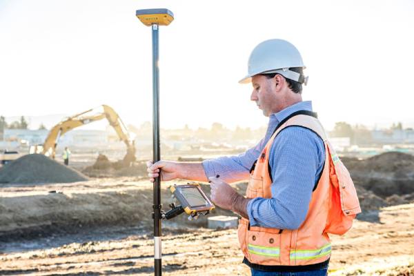
If someone handed you a Nokkia 5110 to run your business you would likely laugh them out of the room…..after playing snake for a few minutes. The same could also be said for today’s smart phone, if it doesn’t have a data plan then it’s just a phone and not very smart at all, certainly not smart enough to help run your business. I could even go one step further and suggest that if your data isn’t centrally stored and accessible remotely then you might as well keep playing snake on the 5110. So why do I still see so many projects and surveyors using old data collectors when we are all using smartphones in our daily lives?
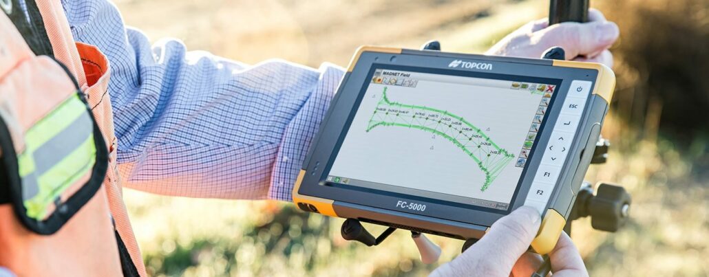
Now that you’ve made the easy decision to upgrade your old data collector to a modern tablet, what should you look for in a tablet to get the best bang for your buck? Not all tablets are the same, the surveying profession has unique requirements and sometimes it’s the small things that can make a big difference. Here are my top 7 features to get the most from your upgrade. 1. Battery Life Intel has made powerful fanless processors that have very low power consumption. However, the larger screen format of the tablet has a big impact on the battery life. A typical survey day would also include the Bluetooth and modem running full time, which further impacts

There has been a big trend in the global software industry away from buying and ‘owning’ a software licence in favour of taking out a monthly, quarterly or annual subscription. Whilst some survey software companies have been slow to roll out this new subscription or in some cases Software as a Service (SaaS) model, some developers are leading the charge and offering a full field to office workflow solution that can deliver big cost savings and dramatic productivity improvements. It’s likely that the computer you’re reading this on has several software packages already on a subscription based model. Microsoft office launched its 365 solution in 2011 and more recently Autodesk transferred its suites to a subscription only model.
Geospatial and positioning company Aptella announces the acquisition of RDS Australia, which provides on-board weighing solutions for heavy machinery such as loaders, excavators and telehandlers. Aptella will sell and support RDS weighing systems for earthmoving, mining and logistics equipment throughout Australia and South East Asia. The agreement follows the recent acquisition of RDS Technology and its parent company Digi-Star LLC by Topcon Positioning Group in March 2015. “As Topcon’s exclusive Australian partner for geospatial and positioning technology, we are delighted to announce the acquisition agreement with the local RDS Technology provider, RDS Australia,” said Harry Katsanevas, Aptella Business Manager for Machine Systems. “By combining RDS Australia’s know how and experience with Aptella’ national sales and technical support team,
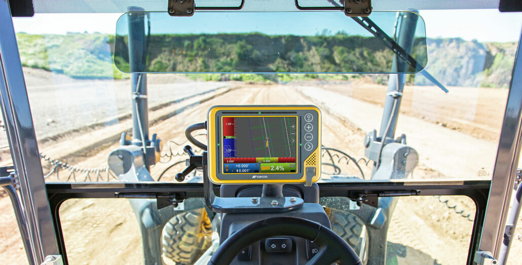
In April, we brought you the news that Topcon would be releasing a new range of Machine Control solutions which included a faster, responsive MC-i4 GNSS receiver and an updated Control box, the GX-55. As with all Topcon products, the new solutions are compatible for all makes and models of machine offering the ultimate flexibility for either aftermarket, retrofit option or a change to a factory-fitted solution. Building on the success of its predecessor, the GX-60, the new GX-55 control box offers a range of new features to make getting to grade faster and easier. The new control box includes integrated grade indicator LED light bars for a quick visual grade reference. Plus the customisable grade tones provide
Australia’s civil construction industry is sophisticated and world-leading, with high adoption rates of the latest technology compared with other developed nations. That’s not to say that adoption is high, far from it, as construction remains a serial productivity underperformer and spends less than half the global manufacturing industry on automation. That said, technology including machine control and state-of-the-art surveying tools such as GNSS, robotic total stations, 3D laser scanning and Remotely Piloted Aircraft Systems (RPAS) are commonplace on most major civil projects in this country. The Australian market is unique in that it aligns more in accuracy requirements to European standards, yet sources the vast majority of its machinery from the United States. This throws up some anomalies
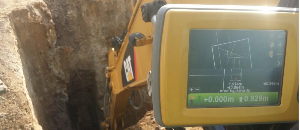
Victorian-based Sure Constructions is a road and civil construction company servicing the greater Gippsland Area with locations in the west, south and far east. Businesses Gippsland Pipelines (Sewer and Water infrastructure) and Stable Roads (Road Stabilisation) are both owned by Sure Constructions and are an integral part of the dynamic Sure group. Associate Director and Director of Gippsland Pipelines Mark Steggall loves to explore the use of the latest technology to improve productivity, safety and efficiency. Topcon GPS technology has been in the business for nine years with machine control being utilised for the last seven. Recently, Mr Steggall and his colleagues used Topcon GPS technology to excavate two deep shafts over 6.5m in depth using a combination
Topcon Positioning Group announces increased integration in the Autodesk and Topcon reality data workflow that is designed to increase project efficiency. Raw scan data from the Topcon GLS-2000 laser scanner can now be taken directly into Autodesk® ReCap 360® and ReCap 360 Pro® with no intermediate software conversion steps necessary. This integration is designed to streamline point cloud analysis to quickly identify conflicts, measure variations and make adjustments at various stages of a construction project. “With the Topcon and Autodesk BIM solution, users can speed up the process by now directly importing their scan data into ReCap 360 and 360 Pro for every step of the point cloud process — registration (Pro only), cleanup, indexing, segmentation and more,”