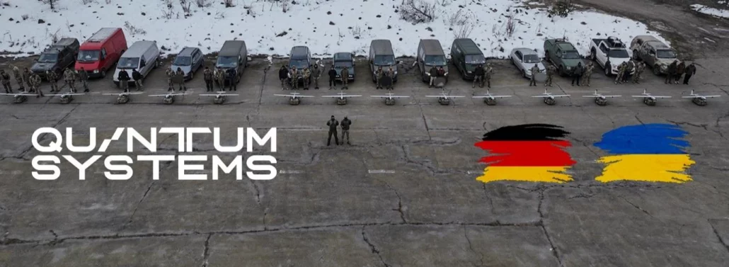
Quantum-Systems GmbH, the dual-use aerial intelligence company that provides multi-sensor data collection drones to government agencies and commercial customers, today announced an order of 300 additional mid-range reconnaissance drones type Vector™ in military support of Ukraine’s armed forces, funded by the German Government. Founded in 2015, Quantum Systems is at the forefront of unmanned aerial system (UAS) development. Its electric vertical take-off and landing (eVTOL) systems boast industry-leading endurance, ease of operation, and reliability, exceeding the performance of conventional UAS platforms. Quantum Systems’ drones bring together the most robust and field-proven systems and commercial speed in development and innovation. Aerial intelligence when it matters The Ministry of Defense of Ukraine has placed a third order of 300 Vector™

Wow… the first 6 months of 2023 has been rather tumultuous in the construction industry, especially the residential sector with inflation, supply chain issues, rapid interest rate rises and housing affordability coming home to roost and making for a difficult and tricky period for the industry to navigate. . However, in spite of all this, the fundamentals that have underpinned the industry for the last 20 years are all still in place and whilst the short and mid-term prospects aren’t so bright, the longer term is still looking quite promising. First, let’s unpack the bad news: the inflationary pressures brought about by global supply issues in the last two years combined with slow land release, lack of skilled
Workshop: Construction Set out July 21st 2023, Victoria Park Golf Club Days Hours Already a Topcon LN-150 user? Click here to register for our exclusive ½ day workshop. Grab your tickets today, places are limited! Get more out of your Topcon LN-150 construction set-out solution with our exclusive ½ day workshop for existing users. In this hands-on session, we’ll cover a range of topics including Digital Traceability, survey fundamentals and MAGNET Field life hacks, with the opportunity to network with peers and answer any questions you may have. After lunch, please stay on for our afternoon exploring complementary solutions, with presentations from existing users as well as live demonstrations of 3D scanning, monitoring solutions including dust and vibration,

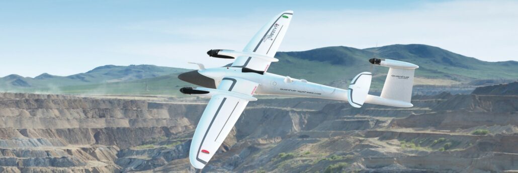
Next Generation drone from Quantum Systems expands operational capabilities, reduces risk, and provides industry-leading aerial intelligence. . Aptella is pleased to announce the availability of Quantum Systems’ new Trinity Pro remotely piloted aircraft system (RPAS) for the Australian and New Zealand market. The new model, with its broad range of sensors, further improves the ROI from its highly successful predecessor the Trinity F90+, and firmly places itself as the premier fixed-wing VTOL drone. “Having seen the new model in action during an exclusive distributor pre-release event in Germany last week, the team at Aptella is excited to introduce this high performance VTOL solution to our local market,” said Gavin Docherty, RPAS Product Manager at Aptella, Quantum Systems’ Australian

Learn more about the key features and how to use the NavVis VLX 3D Laser Scanner in this demonstration with Geoff Preece, Market Development Manager for Scanning at Aptella. Get access to Product brochure, Data sheet, and Point cloud data (e.57) To watch the demo, please fill in the form. Please enable JavaScript in your browser to complete this form.Name *FirstLastCompany* *Email* *Phone* *State* *State*NSWVICQLDSAWATASNTACT Submit Learn more about our 3d laser scanning products and software options
Upgrading surveying techniques for councils For surveyors working with councils and local governments, integrating robotic total stations and GNSS equipment is part of everyday surveying work. Many local councils throughout Australia complete a wide range of geospatial and surveying works. The requirements for each of these jobs varies widely depending on factors like whether the location is within a city or regional town, but these traditional methods of robotic total stations and GNSS equipment are currently commonplace. But a look at new surveying technology has uncovered new surveying options for councils. Some of the best technology for councils in 2023 is supplementing traditional surveying methods with MAGNET software, survey drones, wearable mobile scanning systems, and wireless monitoring –

Supporting regional councils with remote support Remote support for regional councils has become increasingly important in recent years, as local governments continue to rely on modern technologies to carry out their work. In particular, the use of GNSS (Global Navigation Satellite System) technologies has revolutionized the way that councils carry out surveying work in the field, allowing for faster and more accurate data collection than ever before. Using AllDayRTK networks One of the key challenges that regional councils face when carrying out in-field GNSS work is the need for a reliable network positioning infrastructure. Traditionally, this has required the use of personal base stations, which can be costly to set up and maintain. However, with the advent of
From calculating carbon credits to LiDAR mapping, the versatility of aerial mapping applications is expanding at pace. Remotely piloted aircraft systems (RPAS) are fast becoming a mainstay of surveying, engineering and geospatial applications. The technology, computer processing speeds and data integrity have come a long way since their first introduction as aerial mapping instruments in 2011. And it’s fair to say their in-flight stability, battery life and overall reliability have also improved tenfold or more. Intelligent positioning solutions provider Aptella was the first to introduce a survey-grade RPAS in 2011. “We are continuously on the look-out for innovative solutions from around the world that will improve productivity for our customers,” said Gavin Docherty, RPAS manager for the company.