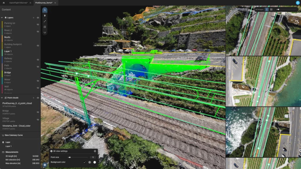
About this workshop This course will introduce you to critical PIX4Dmatic and PIX4Dsurvey workflows. You will learn about best practices for capturing RGB images and creating, managing, analyzing, and sharing 2D and 3D reconstructions of reality. A series of hands-on exercises will demonstrate how to effectively work with PIX4Dmatic and PIX4Dsurvey. Date and time Tuesday, November 1, 2022, 9:00am – 5:30pm Wednesday, November 2, 2022, 9:00am – 5:30pm Attendance on all two days is required. Location: Auckland (address to be confirmed) Price: 1200 NZD (+ taxes) Operating system: Windows Register Objectives Produce accurate 2D and 3D georeferenced representations of reality, including orthomosaics and 3D models Extract vectorized information from results Export results Agenda Lecture Introduction to photogrammetry Introduction to capturing

Southeast Queensland surveying firm invests in NavVis VLX mobile scanning and successfully deploys Senceive deformation monitoring and Omnidots vibration monitoring systems across a range of infrastructure, construction, heritage and utilities projects. Bennett and Bennett has provided land surveying, town planning and spatial services throughout Southeast Queensland for more than 50 years. With more than 100 employees, the company is well resourced for small and large-scale projects and has adapted its business over time to embrace the latest technology and surveying methods. To complement the firm’s terrestrial mapping capabilities, Bennett and Bennett has recently taken delivery of a NavVis VLX wearable mobile mapping platform, sold and supported in Australia and New Zealand by Aptella. Powered by SLAM technology, the
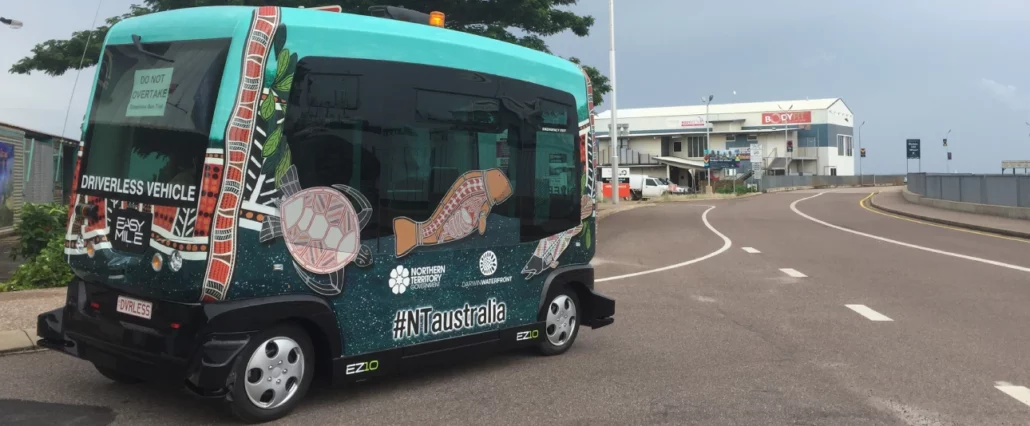
The collaboration will bring the u-blox PointPerfect service’s dm-level positioning accuracies to mass-market applications such as automotive and micromobility. u-blox (SIX:UBXN), a leading global provider of positioning and wireless communication technologies and services, and Aptella, an Australasian provider of intelligent positioning solutions, have signed an MoU of cooperation to expand the availability of global navigation satellite system (GNSS) augmentation services in Australia and New Zealand. The partnership with Aptella is another step on the path to offering customers global coverage of the u-blox PointPerfect GNSS augmentation service. AllDayRTK assisted the Northern Territory’s trial of an autonomous bus shuttle service in Darwin A mass-market-focused offering for Australia, New Zealand Aptella is a well-established provider of real-time kinematic (RTK) GNSS
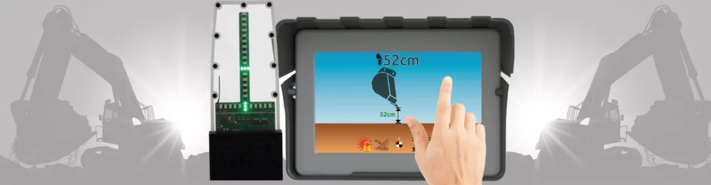
Adding grade control to your excavator comes with a host of benefits. It saves time by getting you to grade faster, reduces or eliminates overcutting and re-work, and can cut labour costs by negating the need for a grade checker. However, for many contractors, justifying the cost when margins are tight enough as it is can be a challenge. iDig is a lower-cost, versatile grade checking system that can be fitted to any make, model or size of excavator and work with multiple buckets, including tilt buckets and augers. There are also options for non-centre pivot machines. “This system is a game changer for contractors that want the benefits of grade control on their excavator, but can’t justify
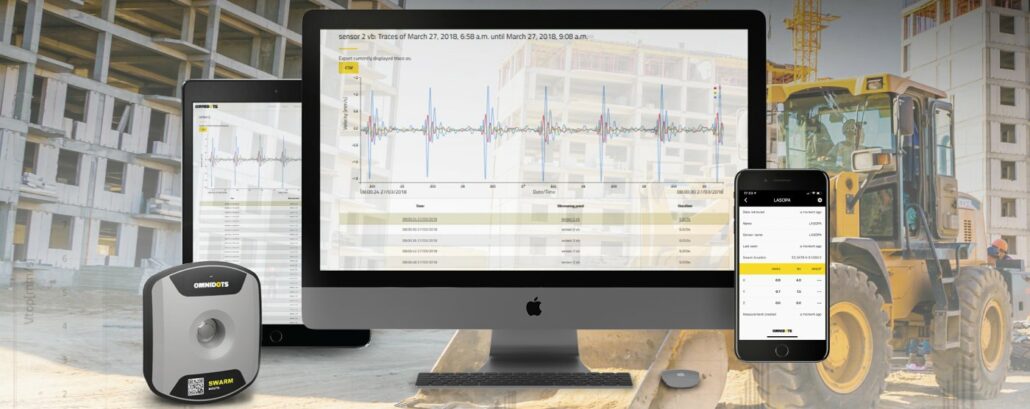
Intelligent positioning solutions provider Aptella to distribute Omnidots’ innovative wireless vibration monitoring platform throughout Australia and New Zealand. Omnidots specialises in easy to setup, autonomous, reliable vibration monitoring systems for use in infrastructure and geophysical applications. Under the agreement, Aptella has been appointed Master Distributor for the Omnidots range. “The Omnidots solution is unique in its capacity to deliver a fully automated, wireless, and integrated vibration monitoring platform that can be installed and setup in minutes,” said Andrew Jones, Monitoring Marketing Development Manager at Aptella. “The Omnidots range compliments our other deformation monitoring solutions and has already received very positive feedback from customers using it for commercial construction and infrastructure projects,” he added. Vibration monitoring is important in
FREE online training and certification with a 12-month Pix4Dmapper subscription! Save NZ $600 Hurry, this offer must end on 30th June 2021 Free training and certification Pix4Dmapper is your must-have photogrammetry software for survey drone data, transforming imagery into digital maps and 3D models for you to analyse, measure and control. Capture: RGB, thermal or multispectral images with any camera Ditigise: Process your survey drone data into digital maps or 3D models Control: Unique rayCloud environment helps you check and control the quality of your data Measure & Inspect: Quickly and accurately measure distances, areas and volumes in a digital environment Collaborate & share: Safely and securely share projects with key More Info Webinar – Overcoming the Challenges
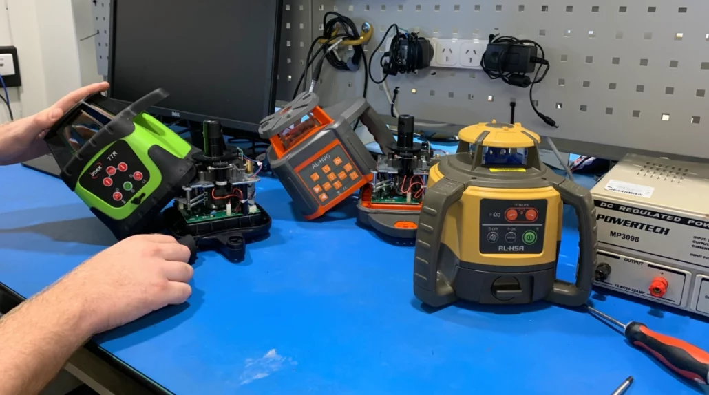
Experts in laser level calibrations! Book your clean and calibration today! Book In Your Laser Level Calibration Service With Our Team Of Experienced Technicians. Visit our service centre in Auckland or book online. Book Online Aptella services all brands and models of laser levels, digital levels and auto levels used in the construction industry. Enquire Now Aptella has service centres in all states and territories of Australia including Sydney, Brisbane, Melbourne, Adelaide, Perth, Canberra, Darwin and Tasmania. With manufacturer trained technicians that can clean, calibrate, repair and service all makes and models of laser levels and construction levels as well as Topcon and Sokkia optical and machine systems technology. If you’re looking to repair or service your laser
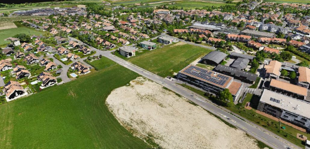
Did You Miss Our Webinar? Don’t Worry, You Can watch Our On-Demand Webinar In this webinar, you’ll learn how Pix4D’s new geospatial solutions – Pix4Dmapper, Pix4Dmatic and Pix4Dsurvey – can help to optimise the surveying and mapping workflows to achieve accurate results and get the relevant information your team needs. Key topics: – Photogrammetry pipeline: processing your data into accurate point clouds, digital surface models (DSM) and orthomosaic – Creation of engineering-ready CAD files from photogrammetry projects – Different user cases – Q&A session Acess On-Demand Webinar Limited Time Offer – Free training and certification FREE Online Training And Certification With A 12-Month Pix4Dmapper Subscription! SAVE NZ $600 Request More Info