Despite its humble beginnings, the company has made a substantial mark on the industry, taking on some large-scale and complex projects that many companies of its size might shy away from. Today, under the next generation’s leadership, the company continues to thrive, consistently pushing the envelope in civil engineering, surveying and marine construction.
One of their most recent and impressive projects is the Shell Cove Boat Harbour Marine Project—a vision that was first proposed by Shellharbour City Council more than 30 years ago. “Our vision was building this brand-new boat harbour inside a landmass, essentially on an old swamp,” Scott Rogers, Civil Engineer Survey Manager at Coastwide Civil explains. “We excavated the old swamp and created a completely new harbour, along with a township around it. It was a massive, multi-billion-dollar development project, involving not just the harbour but also all the foreshore and surrounding housing developments. Coastwide Civil was the principal contractor for the construction of the harbour and the broader township development.”
Overseeing such a large-scale project required a level of precision, safety, and efficiency that made virtual surveying technology essential for success. Enter Virtual Surveyor, a game changing tool that has enabled Coastwide Civil to stay at the forefront of the surveying industry, enhancing their operations on projects like Shell Cove and others.
For Scott Rogers, the key to staying ahead in the competitive surveying industry is harnessing the best technology to improve efficiency, accuracy, and safety. With over 20 years of experience, Scott has worked on a wide range of projects across construction, civil engineering, mining, and more. A focus on providing high-precision, timely results to clients has earned his company a strong reputation. But in an industry that is constantly changing, staying ahead of technological trends is essential.
When Virtual Surveyor by Aptella came into the picture, Scott saw the potential to drastically improve the way his company operates. “Our business is all about accuracy, and we’ve always looked for ways to enhance our processes with technology. Virtual Surveyor was exactly what we needed,” says Scott. “Since we started using it, the software has transformed how we process drone data and handle large, complex survey projects.”
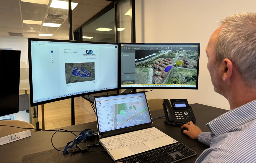
Virtual Surveyor is a powerful software that allows surveyors to transform drone imagery into survey grade data with exceptional precision. For Coastwide Civil, the shift to using Virtual Surveyor was driven by the need for more efficient data processing. Previously, data collection and analysis could take days, often requiring significant resources. However with Virtual Surveyor, Scott and his team say they’re able to process data much faster, freeing up time for more critical tasks.
“We’ve used Virtual Surveyor for several years now, and it has become a key part of our daily operations. Instead of spending days processing data, what once took a whole team now only takes a few hours,” Scott explains. “The software’s ease of use is one of its biggest advantages—it really streamlines our workflow, especially when we’re dealing with large data sets.”
Virtual Surveyor makes it easy to convert high-quality drone images into digital elevation models (DEMs), contours, and other critical survey outputs, allowing Coastwide Civil to provide precise land surveys, even in difficult to reach areas. The software supports all stages of the surveying process, from initial data collection through to analysis and reporting.
“We can immediately process the data, conduct volume calculations, and generate the necessary reports,” Scott adds. “The results are of the same high quality as traditional surveying methods, but the efficiency is greatly improved.”
A key component of the success Coastwide Civil has found with Virtual Surveyor is their ongoing relationship with Aptella. Having worked with Aptella for several years, Scott credits the strong partnership with providing unparalleled support that has been vital to the company’s success.
“Working with Aptella has been an absolute game changer,” Scott says. “The support we get from their team is outstanding. It’s rare to find a partner that genuinely cares about your success and is always available to provide help when you need it. Aptella’s commitment to supporting us as we grow with the technology has been invaluable.”
Their collaboration with Aptella has been a truly hands-on experience, with Scott and his team benefiting from tailored training and troubleshooting support. “We’ve always felt confident in Aptella’s support team,” Scott says. “Whether we need immediate help in the field or assistance back in the office, they are always there with solutions.”
Coastwide Civil doesn’t just use Virtual Surveyor for data processing; they also integrate the software with Tokara, a remote support platform from Aptella, to provide seamless assistance to their team on site. Tokara allows field teams to quickly access technical support from Aptella’s experts, ensuring minimal downtime during projects.
“This integration has been incredibly beneficial,” says Scott. “When we’re out in the field and face a challenge, we can instantly connect to Aptella’s experts through Tokara. This real-time assistance is essential, especially when dealing with complex data sets or site specific issues. It means we’re not wasting time and can keep our projects moving forward smoothly.”
The ability to instantly troubleshoot problems and get direct support through Tokara is a key differentiator. “It’s not just about the software—it’s about the entire ecosystem that Aptella offers. We’ve been able to fully integrate Virtual Surveyor with Tokara, and the two work together seamlessly. That support is critical for us as we manage remote, high stakes projects,” Scott adds.
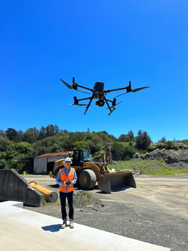
Coastwide Civil uses a variety of RPAS (Remotely Piloted Aircraft Systems) to capture data, but the true power of their drone fleet is unlocked when combined with Virtual Surveyor. While Scott’s team flies DJI Matrice and Phantom 4 RTK drones for their surveying tasks, it’s the powerful software that turns their aerial data into actionable insights.
“The integration between Virtual Surveyor and our drones is fantastic. The software works flawlessly with the data collected, and we get survey-grade accuracy every time,” says Scott. “We’ve been using the same drones for a while, but the addition of Virtual Surveyor has really elevated our capabilities. We get the most out of our drone fleet because the software brings everything together.”
Safety is always a priority for Coastwide Civil, especially on challenging mining or construction sites. By using drones in conjunction with Virtual Surveyor, Scott’s team is able to gather highly accurate data without exposing themselves to the hazards of these dangerous environments.
“Using drones for surveying has vastly improved our safety,” Scott notes. “With Virtual Surveyor processing the drone data, we can deliver super accurate results without putting our team in harm’s way. It’s a win-win—it’s safer, faster, and more cost-effective. It’s a no brainer.”
For Coastwide Civil, the combination of Virtual Surveyor and Tokara, backed by Aptella’s outstanding support, has significantly boosted their efficiency, accuracy, and safety. The long standing and trusted partnership with Aptella has empowered Scott and his team to embrace cutting edge technology that continues to revolutionise their operations.
“Virtual Surveyor has completely transformed the way we approach surveying, and the seamless support we get through Tokara is second to none,” Scott concludes. “If you’re looking for a comprehensive, efficient, and accurate surveying solution, Virtual Surveyor is definitely the answer. We’re proud to recommend Aptella as a partner—they’ve played an integral role in our success, and we look forward to continuing this partnership in the years ahead.”
Reflecting on his journey with Virtual Surveyor and Aptella, Scott acknowledges that while embracing new technology can be intimidating, the benefits far outweigh the initial hurdles. “The first step is always the hardest—there’s a learning curve when implementing new systems,” he admits. “But once you’re using the technology and experiencing its capabilities, the difference it makes is massive. It helps move the company forward in a way that just isn’t possible with traditional methods. It’s a great time to be riding this wave of innovation.”
For Scott and Coastwide Civil, the integration of Virtual Surveyor has already proven to be a game changer. By fully embracing the power of cutting-edge surveying technology, the company has not only increased efficiency but also gained a competitive edge.
“The future of surveying is here, and it’s exciting,” Scott concludes. “Getting started with technology like Virtual Surveyor can seem like a big leap, but once you’re there, it’s incredible. If you’re serious about moving your company forward, the leap is absolutely worth it.”