Plumbing has always demanded precision, but the old ways can often slow you down. You’re pulling string lines and tape measures, working from paper plans that don’t reflect the latest changes, and relying on offsets that disappear the moment excavation begins.
Whether you’re installing drainage systems on residential sites or coordinating complex service runs in commercial buildings, you’re often dealing with skills shortages that stretch your crew thin, survey costs that chew into margins, and the constant need to recheck work because traditional methods can leave too much room for error.
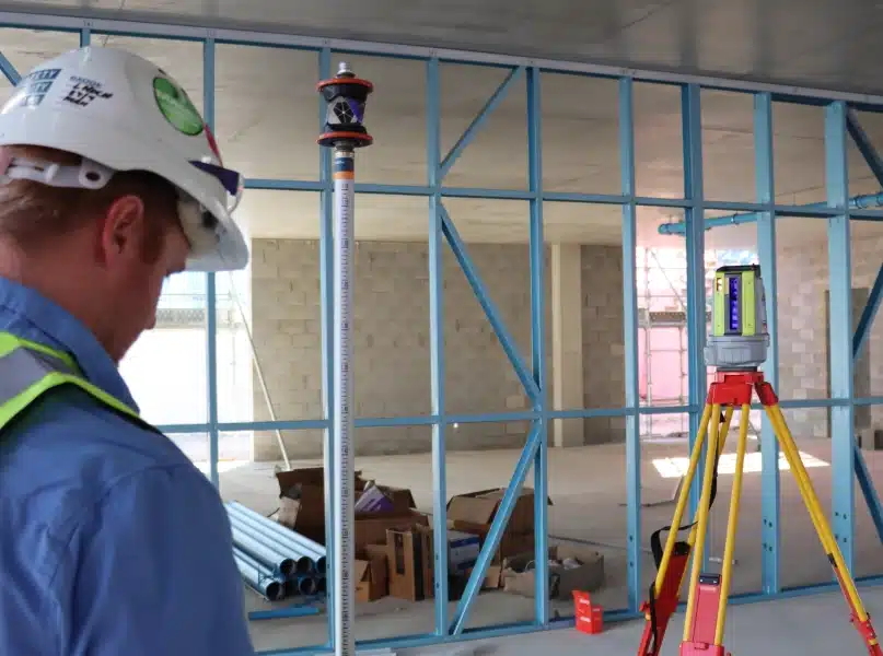
When pipes go in the ground or behind walls, you don’t get a second chance. You need to know positions are right, grades are accurate, and you can prove it.
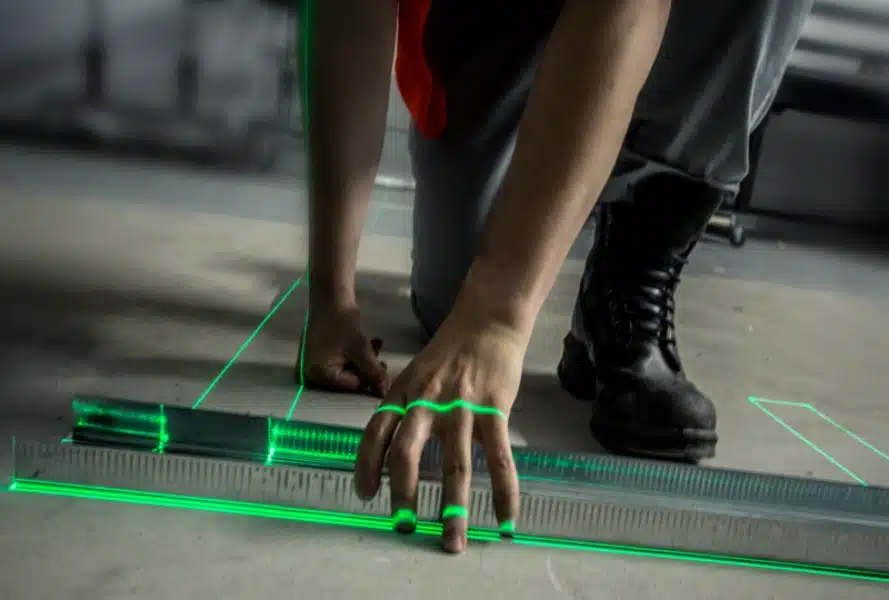
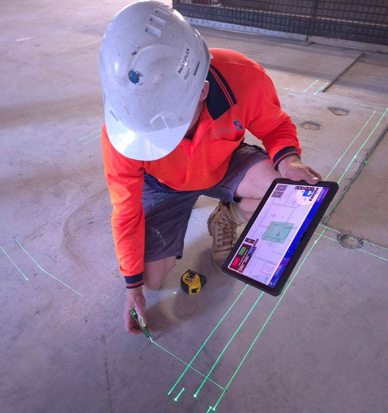
Digital workflows can solve this. Access the latest plans digitally, set out your work with millimetre accuracy, and recheck positions whenever you need to without waiting on surveyors or pulling new measurements from disappearing marks.
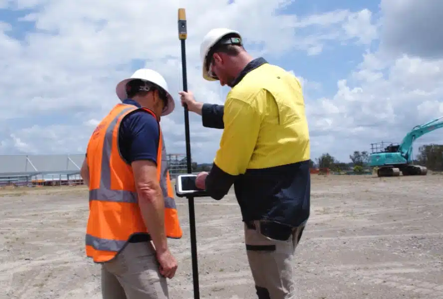
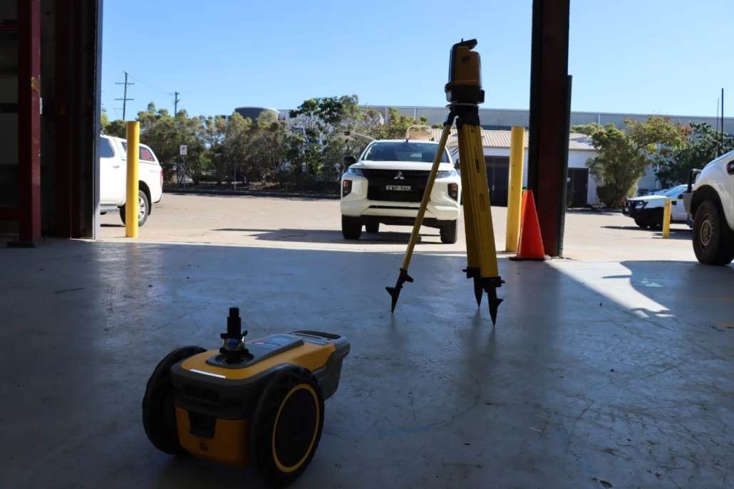
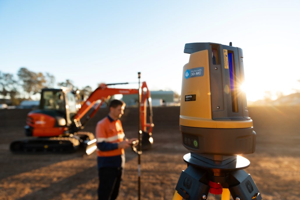
Whether you’re working across open sites where marks get lost in trenches or inside multi-level structures where coordination with other trades is critical, robotic total stations and GPS systems reduce rework, eliminate offset dependency, and let you perform asbuilts that provide real value.
One person can also operate these systems. You’ll use current data, verify your work in real time, and hand over digital records that protect you and add professionalism to your deliverable. From residential in-ground work to high rise mechanical services, we understand what slows plumbing down and how to fix it.
Optical layout delivers sub 3 millimetre accuracy for the precision work plumbing demands. This is your solution when you’re inside structures where GPS can’t reach, when you’re verifying critical grades for sewer and stormwater, or when you need to recheck positions without calling in a surveyor.
For residential plumbers working on in-ground drainage where falls matter, optical systems let you verify invert levels in real time and confirm grades before pipes get buried.
For commercial and high-rise plumbers coordinating complex service installations across multiple levels, optical provides the accuracy you need to position penetrations, check alignment, and ensure services integrate properly with other trades.
The practical advantage is eliminating the juggle of multiple tools. No more switching between dumpy levels, theodolites, line lasers, and tape measures depending on what you’re checking. One robotic total station handles positioning, grade verification, and dimensional control, operated by a single person with full digital traceability.
Whether you’re a residential plumber who needs an affordable entry point into digital workflows or a commercial contractor managing complex mechanical systems, optical layout reduces rework by letting you set out accurately and verify your own work throughout installation.
You’re working from current digital plans, not outdated paper, and you can prove every measurement you’ve made – immediately or in the future.
The Topcon LN-50 is your gateway to modern layout technology. It revolutionises entry-level layout by providing an affordable, easy-to use total station for contractors and builders transitioning to digital
workflows.
The worlds first 3D positioning system designed specifically for construction setout. The LN-160 builds on the foundation of the LN- 50, introducing greater versatility by offering a range of 130m, and the option of using Topcon Field Software.
Lorem ipsum dolor sit amet, consectetur adipiscing elit. Ut elit tellus, luctus nec ullamcorper mattis, pulvinar dapibus leo.
The Topcon GT Series represents the pinnacle of
robotic total station technology, delivering unparalleled accuracy, speed, and reliability for the most demanding projects.
GPS layout is built for the in-ground plumber working across bigger spaces before structures go up. Mark out trench alignments, position manholes, establish drainage runs, and set rough bottom of trench heights across expansive residential or commercial sites with 20 to 30 millimetre accuracy.
You really only need clear sky. No setting up over control points, no line of sight limitations, no waiting for surveyors to establish marks that will be lost as soon as excavation starts. Jump out of your vehicle, turn the rover on, and you’re marking positions.
This is particularly valuable for residential in-ground plumbers working on housing developments or larger residential sites where you’re covering significant ground quickly.
GPS excels at the initial positioning phase when speed matters and tighter tolerances aren’t yet required. Get your major positions established, mark your trench alignments, then switch to optical when you’re installing pipes where critical grades and falls demand millimetre accuracy.
Many plumbers run both systems on the same project because they complement each other perfectly. The software is identical, so you’re not learning two different workflows. You’re simply choosing GPS for rapid positioning across open sites and optical for precision installation work.
Both eliminate your dependency on physical marks and manual offset measurements, letting you verify and recheck positions throughout the job without additional survey costs.
The HiPer CR is an ultralightweight and compact solution that minimises pole weight, ensuring easy mobility and field usability.
The HiPer XR delivers precision and efficiency, tackling your challenges with RTK accuracy and Dynamic TILT Compensation technology for effortless measurements even in difficult conditions. Its anti-jamming capabilities ensure reliable performance, while the lightweight, rugged design withstands harsh environments.
Projected layout systems project complete service plans directly onto ceilings and floors at full scale, transforming how commercial and high-rise plumbers approach internal installations. Instead of marking individual points or pulling measurements from paper plans, projection displays your entire pipe work layout, sprinkler positions, and drainage runs simultaneously.
For plumbers coordinating services in ceiling voids alongside electrical and HVAC contractors, this technology reveals clashes and coordination issues before anyone installs anything. You see exactly where your work intersects with other trades in real time.
This matters most in commercial fit outs and multi-level residential projects where service density in ceiling spaces creates coordination challenges.
Traditional methods require you to mark positions individually, often discovering conflicts only after installation begins. Projected layout eliminates that risk by showing all services from all trades in their installed positions before commitment.
For plumbers working on projects where service coordination drives program and where rework from clashes is expensive, projection technology provides visualisation that prevents problems rather than discovering them later.
While this may exceed needs for simpler residential work, it transforms efficiency on complex commercial installations where multiple trades compete for the same ceiling space.
The Mechasys XR Projector ensures consistent accuracy and enhances the efficiency of your layout operations with a highly productive visual workflow. Whether you’re working on floors or ceilings, its advanced positioning technology provides best-in-class visual projection, adaptable to any job site.
The HP SitePrint automates the marking process for plumbing layouts in commercial and high-rise applications. This system prints reflected ceiling plans directly onto slabs, which you then plumb up to position ceiling mounted services.
Instead of manually marking out complex service layouts point by point, the printer moves across the floor surface and marks your complete design autonomously. Walls, partitions, and ceiling service routing all printed with precision, eliminating string lines, chalk lines, and manual measurement.
For plumbers working on large format commercial projects or high-rise residential buildings with repetitive level layouts, automated marking delivers efficiency that manual methods can’t match.
The system provides the floor level markings you need to plumb up and install ceiling services accurately. While this technology may exceed requirements for smaller residential work, it transforms productivity on projects where marking complexity and scale compound across multiple levels or large commercial spaces.
HP SitePrint is an autonomous, robotic solution that reads 2D plans and prints them directly onto the floor of a construction site. The device is capable of printing not only lines, but other elements such as points, arcs, and text too.
Reality capture creates a complete digital record of installed services before they’re covered over. Using SLAM scanning technology, you can rapidly capture point cloud data showing the exact position and depth of every pipe, connection, and service you’ve installed.
This goes beyond traditional as-built documentation with marked up paper plans. You’re providing a full three-dimensional digital twin showing design versus what was actually built, with millimetre accurate coordinates for every element.
This level of documentation may be mandated on larger commercial and high-rise projects, but it’s valuable regardless.
When you’re installing services that will be buried or closed in behind walls and ceilings, having a complete digital record protects you and adds value to your deliverable.
Instead of relying on memory or notes about where you made that connection six months ago, you’ve got verifiable data. The technology captures everything visible in rapid time frames, creating information you own forever.
For plumbers positioning complex service networks that won’t be accessible after construction, reality capture provides assurance and documentation that traditional methods simply can’t match.
Precision, accuracy, and reliability are central to what you do – they are the core principles of reality capture. And despite rapid changes, tighter budgets, and complex projects with stringent requirements, you’re still expected to do more – scan more, process more, model more, and offer more – with less.
NavVis MLX offers an unrivaled combination of agility, ergonomics, and outstanding data quality from a handheld device. It seamlessly integrates into AEC, surveying, and reality capture workflows both on-site and in-office.Â
Portalcam is the first handheld device that captures reality as interactive 3D environments using breakthrough 3D Gaussian Splatting technology.
The Lixel L2 Pro is a highly integrated, high-precision handheld 3D reconstruction device featuring an all-in-one design and simple one-touch operation developed by XGRIDS.
LixelKity K1 is a compact handheld scanning and modeling device newly introduced by XGRIDS. With a lightweight <1kg body, it integrates 48 MP ×2 panoramic vision modules and a 360° LiDAR, capable of real-time generation of centimeter-level colored 3D models.
Machine guidance integrates positioning technology directly onto excavation equipment, eliminating manual marking entirely for in-ground plumbing work. Instead of using a GPS rover to walk your site spraying paint for trench positions and pipe runs, integrate the system onto your excavator or compact track loader.
The operator views the digital design in cab, sees the bucket position against your plans in real time, and digs to design without anyone marking on the ground.
For residential in-ground plumbers working on developments with trenching and drainage work, machine guidance represents a major productivity shift.
This works with GPS systems for general excavation at 20 to 30 millimetre tolerances or optical systems when you need sub 3-millimetre accuracy for final grade work.
Commercial and industrial plumbers managing large scale site works benefit most, but residential contractors on bigger projects see real value in eliminating the marking person from the crew.
You’re working directly from digital plans, the machine knows where it is at all times, and you’re not losing productivity to layout and verification cycles. It’s a prime solution for plumbers who’ve already adopted GPS or optical layout and want to take the next step.
Ditch setout in the ground. Don’t stress over lost marks or working from offsets. See and dig to design, directly from the comfort of your cab.
Prep for footpaths, garden beds, and retaining walls with precision.
External works teams benefit from MC-Mobile when grading driveways, preparing garden beds, or setting out retaining walls and drainage systems.
Before you excavate or trench, subsurface detection technology locates existing services and utilities. Finding out where electrical, water, gas, and communications lines sit before breaking ground protects you from damaging existing infrastructure, prevents costly service strikes, and keeps your project on schedule.
For plumbers working in built up areas or on sites with existing services, utility location tools are essential to help you work safely and avoid incidents that derail programs and create hazards.
The DXL4 Cable Avoidance Tools from C.Scope represent a significant advance in cable detecting performance.
The MXL4 Precision Locator represents a significant advance in cable detecting and tracing capabilities.
Two versions of the MXL4 are available; the MXL4-D which has full data logging capability, and the MXL4-DBG which has full data logging capability, Bluetoothâ„¢ connectivity and GPS.
Optical layout delivers sub 3 millimetre accuracy for the precision work plumbing demands. This is your solution when you’re inside structures where GPS can’t reach, when you’re verifying critical grades for sewer and stormwater, or when you need to recheck positions without calling in a surveyor.
For residential plumbers working on in-ground drainage where falls matter, optical systems let you verify invert levels in real time and confirm grades before pipes get buried.
For commercial and high-rise plumbers coordinating complex service installations across multiple levels, optical provides the accuracy you need to position penetrations, check alignment, and ensure services integrate properly with other trades.
The practical advantage is eliminating the juggle of multiple tools. No more switching between dumpy levels, theodolites, line lasers, and tape measures depending on what you’re checking. One robotic total station handles positioning, grade verification, and dimensional control, operated by a single person with full digital traceability.
Whether you’re a residential plumber who needs an affordable entry point into digital workflows or a commercial contractor managing complex mechanical systems, optical layout reduces rework by letting you set out accurately and verify your own work throughout installation.
You’re working from current digital plans, not outdated paper, and you can prove every measurement you’ve made – immediately or in the future.
The Topcon LN-50 is your gateway to modern layout technology. It revolutionises entry-level layout by providing an affordable, easy-to use total station for contractors and builders transitioning to digital
workflows.
The worlds first 3D positioning system designed specifically for construction setout. The LN-160 builds on the foundation of the LN- 50, introducing greater versatility by offering a range of 130m, and the option of using Topcon Field Software.
The Topcon GT Series represents the pinnacle of
robotic total station technology, delivering unparalleled accuracy, speed, and reliability for the most demanding projects.
GPS layout is built for the in-ground plumber working across bigger spaces before structures go up. Mark out trench alignments, position manholes, establish drainage runs, and set rough bottom of trench heights across expansive residential or commercial sites with 20 to 30 millimetre accuracy.
You really only need clear sky. No setting up over control points, no line of sight limitations, no waiting for surveyors to establish marks that will be lost as soon as excavation starts. Jump out of your vehicle, turn the rover on, and you’re marking positions.
This is particularly valuable for residential in-ground plumbers working on housing developments or larger residential sites where you’re covering significant ground quickly.
GPS excels at the initial positioning phase when speed matters and tighter tolerances aren’t yet required. Get your major positions established, mark your trench alignments, then switch to optical when you’re installing pipes where critical grades and falls demand millimetre accuracy.
Many plumbers run both systems on the same project because they complement each other perfectly. The software is identical, so you’re not learning two different workflows. You’re simply choosing GPS for rapid positioning across open sites and optical for precision installation work.
Both eliminate your dependency on physical marks and manual offset measurements, letting you verify and recheck positions throughout the job without additional survey costs.
The HiPer CR is an ultralightweight and compact solution that minimises pole weight, ensuring easy mobility and field usability.
The HiPer XR delivers precision and efficiency, tackling your challenges with RTK accuracy and Dynamic TILT Compensation technology for effortless measurements even in difficult conditions. Its anti-jamming capabilities ensure reliable performance, while the lightweight, rugged design withstands harsh environments.
Projected layout systems project complete service plans directly onto ceilings and floors at full scale, transforming how commercial and high-rise plumbers approach internal installations. Instead of marking individual points or pulling measurements from paper plans, projection displays your entire pipe work layout, sprinkler positions, and drainage runs simultaneously.
For plumbers coordinating services in ceiling voids alongside electrical and HVAC contractors, this technology reveals clashes and coordination issues before anyone installs anything. You see exactly where your work intersects with other trades in real time.
This matters most in commercial fit outs and multi-level residential projects where service density in ceiling spaces creates coordination challenges.
Traditional methods require you to mark positions individually, often discovering conflicts only after installation begins. Projected layout eliminates that risk by showing all services from all trades in their installed positions before commitment.
For plumbers working on projects where service coordination drives program and where rework from clashes is expensive, projection technology provides visualisation that prevents problems rather than discovering them later.
While this may exceed needs for simpler residential work, it transforms efficiency on complex commercial installations where multiple trades compete for the same ceiling space.
The Mechasys XR Projector ensures consistent accuracy and enhances the efficiency of your layout operations with a highly productive visual workflow. Whether you’re working on floors or ceilings, its advanced positioning technology provides best-in-class visual projection, adaptable to any job site.
The HP SitePrint automates the marking process for plumbing layouts in commercial and high-rise applications. This system prints reflected ceiling plans directly onto slabs, which you then plumb up to position ceiling mounted services.
Instead of manually marking out complex service layouts point by point, the printer moves across the floor surface and marks your complete design autonomously. Walls, partitions, and ceiling service routing all printed with precision, eliminating string lines, chalk lines, and manual measurement.
For plumbers working on large format commercial projects or high-rise residential buildings with repetitive level layouts, automated marking delivers efficiency that manual methods can’t match.
The system provides the floor level markings you need to plumb up and install ceiling services accurately. While this technology may exceed requirements for smaller residential work, it transforms productivity on projects where marking complexity and scale compound across multiple levels or large commercial spaces.
HP SitePrint is an autonomous, robotic solution that reads 2D plans and prints them directly onto the floor of a construction site. The device is capable of printing not only lines, but other elements such as points, arcs, and text too.
TinySurveyor Plotter is designed for roadworks on even surfaces such as new concrete layers in road construction. The compact design makes it easy to transport and deploy. The high-visibility safety beacon and ultrasound sensors allow the robot to operate safely in spaces with live traffic or other equipment.
Reality capture creates a complete digital record of installed services before they’re covered over. Using SLAM scanning technology, you can rapidly capture point cloud data showing the exact position and depth of every pipe, connection, and service you’ve installed.
This goes beyond traditional as-built documentation with marked up paper plans. You’re providing a full three-dimensional digital twin showing design versus what was actually built, with millimetre accurate coordinates for every element.
This level of documentation may be mandated on larger commercial and high-rise projects, but it’s valuable regardless.
When you’re installing services that will be buried or closed in behind walls and ceilings, having a complete digital record protects you and adds value to your deliverable.
Instead of relying on memory or notes about where you made that connection six months ago, you’ve got verifiable data. The technology captures everything visible in rapid time frames, creating information you own forever.
For plumbers positioning complex service networks that won’t be accessible after construction, reality capture provides assurance and documentation that traditional methods simply can’t match.
Precision, accuracy, and reliability are central to what you do – they are the core principles of reality capture. And despite rapid changes, tighter budgets, and complex projects with stringent requirements, you’re still expected to do more – scan more, process more, model more, and offer more – with less.
NavVis MLX offers an unrivaled combination of agility, ergonomics, and outstanding data quality from a handheld device. It seamlessly integrates into AEC, surveying, and reality capture workflows both on-site and in-office.Â
Portalcam is the first handheld device that captures reality as interactive 3D environments using breakthrough 3D Gaussian Splatting technology.
The Lixel L2 Pro is a highly integrated, high-precision handheld 3D reconstruction device featuring an all-in-one design and simple one-touch operation developed by XGRIDS.
LixelKity K1 is a compact handheld scanning and modeling device newly introduced by XGRIDS. With a lightweight <1kg body, it integrates 48 MP ×2 panoramic vision modules and a 360° LiDAR, capable of real-time generation of centimeter-level colored 3D models.
Machine guidance integrates positioning technology directly onto excavation equipment, eliminating manual marking entirely for in-ground plumbing work. Instead of using a GPS rover to walk your site spraying paint for trench positions and pipe runs, integrate the system onto your excavator or compact track loader.
The operator views the digital design in cab, sees the bucket position against your plans in real time, and digs to design without anyone marking on the ground.
For residential in-ground plumbers working on developments with trenching and drainage work, machine guidance represents a major productivity shift.
This works with GPS systems for general excavation at 20 to 30 millimetre tolerances or optical systems when you need sub 3-millimetre accuracy for final grade work.
Commercial and industrial plumbers managing large scale site works benefit most, but residential contractors on bigger projects see real value in eliminating the marking person from the crew.
You’re working directly from digital plans, the machine knows where it is at all times, and you’re not losing productivity to layout and verification cycles. It’s a prime solution for plumbers who’ve already adopted GPS or optical layout and want to take the next step.
Ditch setout in the ground. Don’t stress over lost marks or working from offsets. See and dig to design, directly from the comfort of your cab.
Prep for footpaths, garden beds, and retaining walls with precision.
External works teams benefit from MC-Mobile when grading driveways, preparing garden beds, or setting out retaining walls and drainage systems.
Before you excavate or trench, subsurface detection technology locates existing services and utilities. Finding out where electrical, water, gas, and communications lines sit before breaking ground protects you from damaging existing infrastructure, prevents costly service strikes, and keeps your project on schedule.
For plumbers working in built up areas or on sites with existing services, utility location tools are essential to help you work safely and avoid incidents that derail programs and create hazards.
The DXL4 Cable Avoidance Tools from C.Scope represent a significant advance in cable detecting performance.
Two versions of the DXL4 are available; the DXL4-D which has full data logging capability, and the DXL4-DBG which has full data logging capability, Bluetoothâ„¢ connectivity and GPS.
The MXL4 Precision Locator represents a significant advance in cable detecting and tracing capabilities.
Two versions of the MXL4 are available; the MXL4-D which has full data logging capability, and the MXL4-DBG which has full data logging capability, Bluetoothâ„¢ connectivity and GPS.
Aptella has tailored the Tokara service to deliver benefits for a wide range of stakeholders
involved in a civil construction project, including: