Solution Ready for Electricians

Electrical work has always relied on accuracy, but the way it’s traditionally done can slow you down. You’re marking out trenches with tapes and spray paint, transferring dimensions from paper plans, and working off offsets that shift once excavation or concrete pours begin.

Whether you’re running in-ground conduits across a subdivision or setting light poles, pits, and distribution boards on a commercial site, small errors compound quickly. A misplaced conduit affects other services. A pole out of tolerance becomes a compliance issue. A deck setout that is a few millimetres off can disrupt every trade that follows.

Read more

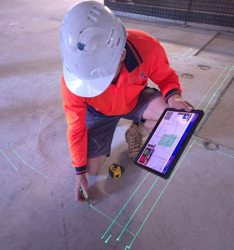
Internally, it doesn’t get easier. You’re coordinating deck penetrations before the pour, setting out cable tray routes, and managing internal fit-off in environments where space is tight and changes are constant. Skills shortages mean your leading hands are stretched, and waiting on surveyors or rechecking measurements eats into productivity.

When conduits are buried or penetrations are cast into concrete, there’s no easy fix. You need confidence that locations are correct, heights are right and everything aligns with the latest revision.

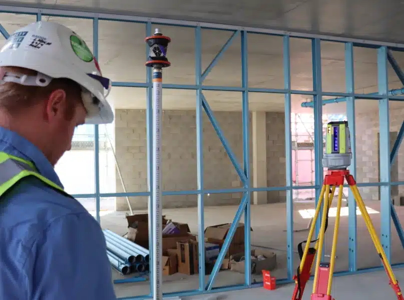
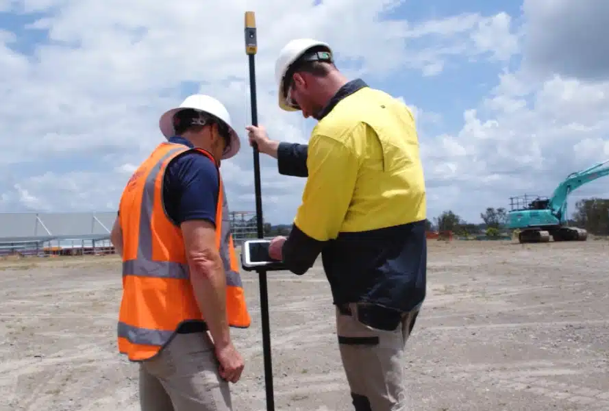
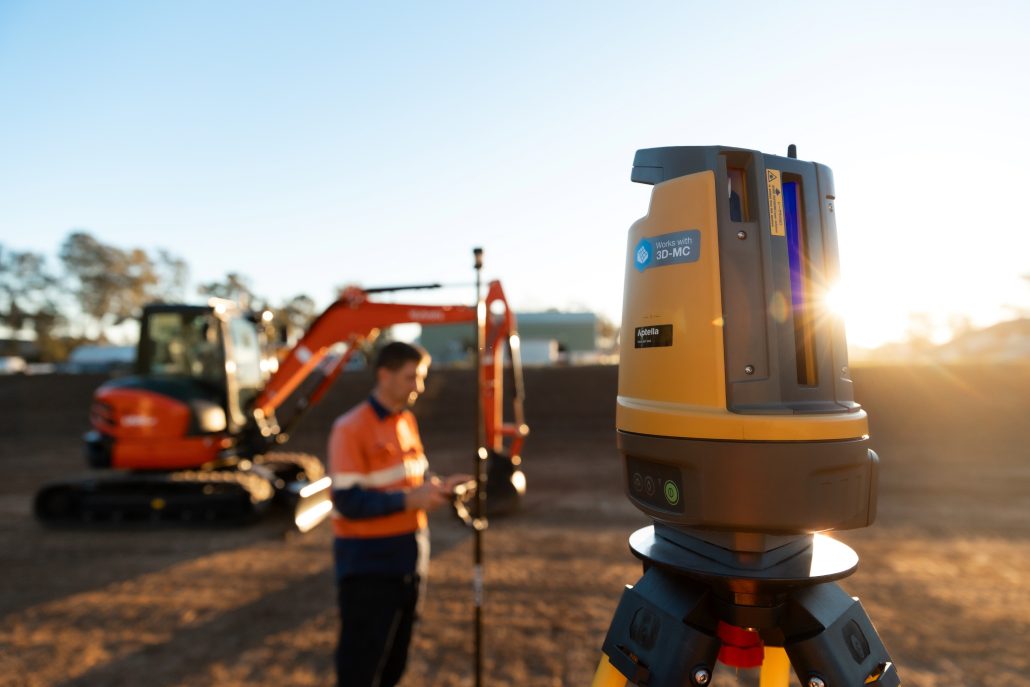
Digital workflows change that. Access current drawings on site, set out trenches, pole positions, pits, and boards with millimetre accuracy, and recheck instantly without relying on disappearing marks or external support.

Across open sites and multi-level structures, robotic total stations and GPS systems reduce rework, remove dependence on offsets, and allow you to capture asbuilts that demonstrate compliance and quality.

One person can operate the system, verify positions in real time, and produce digital records that protect your business. From residential subdivisions to complex commercial fit-outs, we understand the pressure electricians work under and how the right technology keeps projects moving with confidence.

Optical layout delivers sub 3 millimetre accuracy for the precision electrical work demands. This is your solution when you’re inside structures where GPS cannot reach, when you’re setting out deck penetrations before a pour, or when you need to verify positions without relying on external survey support.

For electrical contractors working on in-ground services around buildings and infrastructure, optical systems let you position conduits, pits, and distribution boards with confidence and recheck alignment before anything is buried or cast in.

Read more

On commercial and multi-level projects, optical provides the accuracy required to set out cable tray routes, switchboards, light pole bases, and penetrations so they align with structure and other trades. When tolerances are tight and coordination matters, being a few millimetres out can create problems that ripple across the job.

The practical advantage is consolidating your tools. No more switching between tapes, lasers, dumpy levels, and chalk lines depending on the task. One robotic total station handles positioning, alignment, and dimensional control, operated by a single person with full digital traceability.

Whether you’re a contractor looking for a practical entry into digital layout or a commercial team managing complex installations across multiple levels, optical layout reduces rework by letting you set out accurately and verify your own work throughout the project.

You’re working from current digital plans, not marked-up prints, and you can prove every location and height you’ve installed, both at handover and well into the future.

Topcon LN-50 3D Construction Laser

Topcon LN-50

The Topcon LN-50 is your gateway to modern layout technology. It revolutionises entry-level layout by providing an affordable, easy-to use total station for contractors and builders transitioning to digital
workflows.

LN-160

Topcon LN-160

The worlds first 3D positioning system designed specifically for construction setout. The LN-160 builds on the foundation of the LN- 50, introducing greater versatility by offering a range of 130m, and the option of using Topcon Field Software.

Topcon GT-1500 Total Station

Topcon GT Series

The Topcon GT Series represents the pinnacle of
robotic total station technology, delivering unparalleled accuracy, speed, and reliability for the most demanding projects.

GPS layout is built for the electrical contractor working in-ground across open sites before structures go up. Mark out trench alignments, position pits and conduits, set light pole locations, and establish distribution board pads across large residential estates or commercial developments with 20 to 30 millimetre accuracy.

You really only need clear sky. No setting up over control points, no line of sight limitations, and no waiting on marks that disappear once excavation starts. Step out, power up the rover, and start positioning.

Read more

This is particularly valuable for contractors delivering subdivisions, infrastructure upgrades, or large footprint projects where you’re covering serious ground and speed matters. When you’re trenching long runs or coordinating multiple crews, being able to move freely without constant setup keeps productivity high.

GPS excels during the initial positioning phase when tolerances are practical but not yet critical. Establish your trench routes, pole positions, and pit locations quickly, then transition to optical when you’re setting precise heights, aligning switchboards, or coordinating penetrations inside the structure.

Many electrical contractors run both systems on the same project because they complement each other. The software environment remains consistent, so you’re not learning two separate workflows. You’re simply choosing GPS for rapid layout across open sites and optical for precision work where millimetres matter.

Both remove dependence on physical marks and manual offsets, allowing you to recheck positions at any point without additional survey costs and without losing momentum on site.

hiper cr topcon gnss

Topcon Hiper CR

The HiPer CR is an ultralightweight and compact solution that minimises pole weight, ensuring easy mobility and field usability.

Topcon hiper xr GNSS receiver

Topcon Hiper XR

The HiPer XR delivers precision and efficiency, tackling your challenges with RTK accuracy and Dynamic TILT Compensation technology for effortless measurements even in difficult conditions. Its anti-jamming capabilities ensure reliable performance, while the lightweight, rugged design withstands harsh environments.

Projected layout systems project complete electrical service plans directly onto ceilings and floors at full scale, changing how commercial and high-rise electricians approach internal installations. Instead of marking individual points or pulling dimensions from drawings, projection displays your cable tray routes, lighting layouts, containment runs, and device locations all at once.

For electricians coordinating in dense ceiling voids alongside plumbing and mechanical trades, this technology exposes clashes before anyone drills, fixes, or hangs a single bracket.

Read more

You see exactly where your trays intersect with ductwork, where lighting conflicts with sprinkler lines, and where clearances become tight, in real time.

This matters most on commercial fit-outs, hospitals, data centres, and multi-level residential builds where service congestion drives risk and program pressure is high. When multiple trades are working in the same zone, small layout errors quickly become costly rework.

Traditional methods require setting out points individually and relying on coordination drawings, often uncovering conflicts only once installation is underway. Projected layout removes that guesswork by showing coordinated services in their true installed positions before you commit labour and materials.

For electrical contractors delivering complex projects where coordination defines success, projection technology shifts the focus from reacting to clashes to preventing them entirely.

While it may be more than what’s required for straightforward residential work. It significantly improves speed, clarity, and confidence on high-density commercial installations where ceiling space is at a premium and mistakes are expensive.

Mechasys XR Projector available in Australia | Construction Layout Projector

Mechasys XR Projector​

The Mechasys XR Projector ensures consistent accuracy and enhances the efficiency of your layout operations with a highly productive visual workflow. Whether you’re working on floors or ceilings, its advanced positioning technology provides best-in-class visual projection, adaptable to any job site.

Automated layout with the HP SitePrint transforms how electrical contractors mark out complex commercial and high-rise projects. The system prints reflected ceiling plans directly onto the slab, giving you accurate floor markings that you can plumb up to position cable trays, lighting, containment, and other ceiling mounted services.

Instead of setting out hundreds of points manually, the printer moves across the floor autonomously and marks your coordinated design in one continuous process.

Read more

Walls, partitions, device locations, tray routes, and service pathways are printed with precision, removing the need for string lines, chalk lines, and repetitive tape measurements.

For electricians working on large commercial builds, hospitals, data centres, or multi-level residential towers with repeating floor plates, automated marking delivers consistency and speed that manual methods struggle to achieve. When each level mirrors the one below, the efficiency gains multiply.

The system gives you clear, durable slab markings that support accurate plumb-up and installation of ceiling services, reducing interpretation errors and coordination mistakes.

While this level of automation may not suit smaller residential projects, it significantly improves productivity and accuracy on jobs where layout density, repetition, and scale drive both risk and opportunity.

HP Siteprint
hp siteprint construction layout robot

HP Siteprint

HP SitePrint is an autonomous, robotic solution that reads 2D plans and prints them directly onto the floor of a construction site. The device is capable of printing not only lines, but other elements such as points, arcs, and text too.

NavVis MLX Handheld 3D Laser Scanner

Reality capture creates a complete digital record of installed electrical services before they’re covered or energised. using SLAM scanning technology, you can rapidly capture point cloud data that shows the exact position of conduits, cable trays, penetrations, pits, switchboards, and containment systems as they were built.

This goes well beyond marked-up drawings or basic as-built notes. You’re delivering a three-dimensional digital twin that compares design intent with what was actually installed, with accurate spatial data tied to real-world coordinates.

Read more

On larger commercial and high-rise projects this level of documentation may be specified, but its value extends far beyond compliance.

When conduits are buried, slabs are poured, or ceilings are closed, access disappears. Having a verified digital record protects your business if questions arise later about location, depth, or routing. It also provides clarity for future maintenance, upgrades, or fault finding.

Instead of relying on memory or archived PDFs to determine where a service was run months or years ago, you have measurable data. The capture process is fast and non-intrusive, creating a permanent visual and spatial record of everything visible at the time of scan.

For electrical contractors delivering complex service networks that will soon be hidden behind concrete and plasterboard, reality capture provides a level of assurance, transparency, and professionalism that traditional as-built methods cannot match.

NavVis VLX 3 Wearable laser scanner

NavVis VLX3

Precision, accuracy, and reliability are central to what you do – they are the core principles of reality capture. And despite rapid changes, tighter budgets, and complex projects with stringent requirements, you’re still expected to do more – scan more, process more, model more, and offer more – with less.

portalcam

XGRIDS PortalCam

Portalcam is the first handheld device that captures reality as interactive 3D environments using breakthrough 3D Gaussian Splatting technology.

lixel l2pro real-time scanning and modeling device

XGRIDS Lixel L2 Pro​

The Lixel L2 Pro is a highly integrated, high-precision handheld 3D reconstruction device featuring an all-in-one design and simple one-touch operation developed by XGRIDS.

lixel l2pro real-time scanning and modeling device

XGRIDS LixelKity K1

LixelKity K1 is a compact handheld scanning and modeling device newly introduced by XGRIDS. With a lightweight <1kg body, it integrates 48 MP ×2 panoramic vision modules and a 360° LiDAR, capable of real-time generation of centimeter-level colored 3D models.

Machine guidance integrates positioning technology directly onto excavation equipment, removing the need for manual marking on in-ground electrical projects. Instead of walking the site with a GPS rover to mark trench routes for conduits and service runs, the system is installed on your excavator or compact track loader.

The operator sees the digital design in the cab, tracks bucket position against the plan in real time, and excavates to design without anyone marking lines on the ground.

Read more

For electrical contractors delivering subdivisions, infrastructure upgrades, or large commercial developments, this represents a significant productivity gain. Trench alignments for conduits, pit excavations, and footing preparation for light poles can all be completed directly from the model.

The system works with GPS for general excavation at 20 to 30 millimetre tolerances, and can integrate with optical control when tighter accuracy is required for final levels, pole bases, or critical interfaces.

Electricians working on large scale sites see the greatest impact, but even residential crews benefit from removing the dedicated layout role and reducing double handling.

You’re working from current digital plans, the machine always knows its position, and excavation progresses without repeated marking and verification cycles. For electrical contractors already using GPS or optical layout, machine guidance is the logical next step in driving efficiency and control across in-ground works.

topcon mc -mobile

MC-Mobile - Track Loader

Ditch setout in the ground. Don’t stress over lost marks or working from offsets. See and dig to design, directly from the comfort of your cab.

The MXL4 multi-frequency Precision Pipe & Cable Locator.

Before you trench or excavate for new conduits and services, subsurface detection technology helps you locate existing underground infrastructure. Identifying live electrical, communications, water, and gas lines before breaking ground protects your crew, prevents service strikes, and avoids costly shutdowns and delays.

For electrical contractors working in built-up environments, brownfield sites, or around existing assets, knowing exactly what is below the surface is critical. Damaging a live cable is not just a program issue, it is a serious safety risk.

Read more

Utility location tools give you clarity before machines start moving. You can plan trench routes with confidence, adjust alignments where required, and reduce the uncertainty that often surrounds retrofit or upgrade projects.

Whether you’re installing new power to a subdivision, upgrading site infrastructure, or extending services within an operational facility, subsurface detection supports safer excavation, better decision making, and stronger risk control from day one.

c-scope DXL4 Cable Avoidance Tool

C.Scope DXL4

The DXL4 Cable Avoidance Tools from C.Scope represent a significant advance in cable detecting performance.

MXL4 Precision Pipe & Cable Locator.

C.Scope MXL4

The MXL4 Precision Locator represents a significant advance in cable detecting and tracing capabilities.

Two versions of the MXL4 are available; the MXL4-D which has full data logging capability, and the MXL4-DBG which has full data logging capability, Bluetoothâ„¢ connectivity and GPS.

Optical layout delivers sub 3 millimetre accuracy for the precision electrical work demands. This is your solution when you’re inside structures where GPS cannot reach, when you’re setting out deck penetrations before a pour, or when you need to verify positions without relying on external survey support.

For electrical contractors working on in-ground services around buildings and infrastructure, optical systems let you position conduits, pits, and distribution boards with confidence and recheck alignment before anything is buried or cast in.

Read more

On commercial and multi-level projects, optical provides the accuracy required to set out cable tray routes, switchboards, light pole bases, and penetrations so they align with structure and other trades. When tolerances are tight and coordination matters, being a few millimetres out can create problems that ripple across the job.

The practical advantage is consolidating your tools. No more switching between tapes, lasers, dumpy levels, and chalk lines depending on the task. One robotic total station handles positioning, alignment, and dimensional control, operated by a single person with full digital traceability.

Whether you’re a contractor looking for a practical entry into digital layout or a commercial team managing complex installations across multiple levels, optical layout reduces rework by letting you set out accurately and verify your own work throughout the project.

You’re working from current digital plans, not marked-up prints, and you can prove every location and height you’ve installed, both at handover and well into the future.

Browse our solutions for Optical Layout

Topcon LN-50 3D Construction Laser

Topcon LN-50

The Topcon LN-50 is your gateway to modern layout technology. It revolutionises entry-level layout by providing an affordable, easy-to use total station for contractors and builders transitioning to digital
workflows.

LN-160

Topcon LN-160

The worlds first 3D positioning system designed specifically for construction setout. The LN-160 builds on the foundation of the LN- 50, introducing greater versatility by offering a range of 130m, and the option of using Topcon Field Software.

Topcon GT-1500 Total Station

Topcon GT Series

The Topcon GT Series represents the pinnacle of
robotic total station technology, delivering unparalleled accuracy, speed, and reliability for the most demanding projects.

GPS layout is built for the electrical contractor working in-ground across open sites before structures go up. Mark out trench alignments, position pits and conduits, set light pole locations, and establish distribution board pads across large residential estates or commercial developments with 20 to 30 millimetre accuracy.

You really only need clear sky. No setting up over control points, no line of sight limitations, and no waiting on marks that disappear once excavation starts. Step out, power up the rover, and start positioning.

Read more

This is particularly valuable for contractors delivering subdivisions, infrastructure upgrades, or large footprint projects where you’re covering serious ground and speed matters. When you’re trenching long runs or coordinating multiple crews, being able to move freely without constant setup keeps productivity high.

GPS excels during the initial positioning phase when tolerances are practical but not yet critical. Establish your trench routes, pole positions, and pit locations quickly, then transition to optical when you’re setting precise heights, aligning switchboards, or coordinating penetrations inside the structure.

Many electrical contractors run both systems on the same project because they complement each other. The software environment remains consistent, so you’re not learning two separate workflows. You’re simply choosing GPS for rapid layout across open sites and optical for precision work where millimetres matter.

Both remove dependence on physical marks and manual offsets, allowing you to recheck positions at any point without additional survey costs and without losing momentum on site.

Browse our solutions for GNSS Layout

hiper cr topcon gnss

Topcon HiPer CR

The HiPer CR is an ultralightweight and compact solution that minimises pole weight, ensuring easy mobility and field usability.

Topcon hiper xr GNSS receiver

Topcon Hiper XR

The HiPer XR delivers precision and efficiency, tackling your challenges with RTK accuracy and Dynamic TILT Compensation technology for effortless measurements even in difficult conditions. Its anti-jamming capabilities ensure reliable performance, while the lightweight, rugged design withstands harsh environments.

Projected layout systems project complete electrical service plans directly onto ceilings and floors at full scale, changing how commercial and high-rise electricians approach internal installations. Instead of marking individual points or pulling dimensions from drawings, projection displays your cable tray routes, lighting layouts, containment runs, and device locations all at once.

For electricians coordinating in dense ceiling voids alongside plumbing and mechanical trades, this technology exposes clashes before anyone drills, fixes, or hangs a single bracket.

Read more

You see exactly where your trays intersect with ductwork, where lighting conflicts with sprinkler lines, and where clearances become tight, in real time.

This matters most on commercial fit-outs, hospitals, data centres, and multi-level residential builds where service congestion drives risk and program pressure is high. When multiple trades are working in the same zone, small layout errors quickly become costly rework.

Traditional methods require setting out points individually and relying on coordination drawings, often uncovering conflicts only once installation is underway. Projected layout removes that guesswork by showing coordinated services in their true installed positions before you commit labour and materials.

For electrical contractors delivering complex projects where coordination defines success, projection technology shifts the focus from reacting to clashes to preventing them entirely.

While it may be more than what’s required for straightforward residential work. It significantly improves speed, clarity, and confidence on high-density commercial installations where ceiling space is at a premium and mistakes are expensive.

Browse our solutions for Projected Layout

Mechasys XR Projector available in Australia | Construction Layout Projector

Mechasys XR Projector​

The Mechasys XR Projector ensures consistent accuracy and enhances the efficiency of your layout operations with a highly productive visual workflow. Whether you’re working on floors or ceilings, its advanced positioning technology provides best-in-class visual projection, adaptable to any job site.

Automated layout with the HP SitePrint transforms how electrical contractors mark out complex commercial and high-rise projects. The system prints reflected ceiling plans directly onto the slab, giving you accurate floor markings that you can plumb up to position cable trays, lighting, containment, and other ceiling mounted services.

Instead of setting out hundreds of points manually, the printer moves across the floor autonomously and marks your coordinated design in one continuous process.

Read more

Walls, partitions, device locations, tray routes, and service pathways are printed with precision, removing the need for string lines, chalk lines, and repetitive tape measurements.

For electricians working on large commercial builds, hospitals, data centres, or multi-level residential towers with repeating floor plates, automated marking delivers consistency and speed that manual methods struggle to achieve. When each level mirrors the one below, the efficiency gains multiply.

The system gives you clear, durable slab markings that support accurate plumb-up and installation of ceiling services, reducing interpretation errors and coordination mistakes.

While this level of automation may not suit smaller residential projects, it significantly improves productivity and accuracy on jobs where layout density, repetition, and scale drive both risk and opportunity.

Browse our solutions for Automated Systems

hp siteprint construction layout robot

HP Siteprint

HP SitePrint is an autonomous, robotic solution that reads 2D plans and prints them directly onto the floor of a construction site. The device is capable of printing not only lines, but other elements such as points, arcs, and text too.

Reality capture creates a complete digital record of installed electrical services before they’re covered or energised. using SLAM scanning technology, you can rapidly capture point cloud data that shows the exact position of conduits, cable trays, penetrations, pits, switchboards, and containment systems as they were built.

This goes well beyond marked-up drawings or basic as-built notes. You’re delivering a three-dimensional digital twin that compares design intent with what was actually installed, with accurate spatial data tied to real-world coordinates.

Read more

On larger commercial and high-rise projects this level of documentation may be specified, but its value extends far beyond compliance.

When conduits are buried, slabs are poured, or ceilings are closed, access disappears. Having a verified digital record protects your business if questions arise later about location, depth, or routing. It also provides clarity for future maintenance, upgrades, or fault finding.

Instead of relying on memory or archived PDFs to determine where a service was run months or years ago, you have measurable data. The capture process is fast and non-intrusive, creating a permanent visual and spatial record of everything visible at the time of scan.

For electrical contractors delivering complex service networks that will soon be hidden behind concrete and plasterboard, reality capture provides a level of assurance, transparency, and professionalism that traditional as-built methods cannot match.

NavVis MLX Handheld 3D Laser Scanner

Browse our solutions for Reality Capture

NavVis VLX 3 Wearable laser scanner

NavVis VLX3

Precision, accuracy, and reliability are central to what you do – they are the core principles of reality capture. And despite rapid changes, tighter budgets, and complex projects with stringent requirements, you’re still expected to do more – scan more, process more, model more, and offer more – with less.

NavVis MLX Handheld 3D Laser Scanner

NavVis MLX

NavVis MLX offers an unrivaled combination of agility, ergonomics, and outstanding data quality from a handheld device. It seamlessly integrates into AEC, surveying, and reality capture workflows both on-site and in-office. 

portalcam

XGRIDS PortalCam

Portalcam is the first handheld device that captures reality as interactive 3D environments using breakthrough 3D Gaussian Splatting technology.

lixel l2pro real-time scanning and modeling device

XGRIDS Lixel L2 Pro

The Lixel L2 Pro is a highly integrated, high-precision handheld 3D reconstruction device featuring an all-in-one design and simple one-touch operation developed by XGRIDS.

LixelKity K1 - Handheld 3D Scanner

XGRIDS LixelKity K1

LixelKity K1 is a compact handheld scanning and modeling device newly introduced by XGRIDS. With a lightweight <1kg body, it integrates 48 MP ×2 panoramic vision modules and a 360° LiDAR, capable of real-time generation of centimeter-level colored 3D models.

Machine guidance integrates positioning technology directly onto excavation equipment, removing the need for manual marking on in-ground electrical projects. Instead of walking the site with a GPS rover to mark trench routes for conduits and service runs, the system is installed on your excavator or compact track loader.

The operator sees the digital design in the cab, tracks bucket position against the plan in real time, and excavates to design without anyone marking lines on the ground.

Read more

For electrical contractors delivering subdivisions, infrastructure upgrades, or large commercial developments, this represents a significant productivity gain. Trench alignments for conduits, pit excavations, and footing preparation for light poles can all be completed directly from the model.

The system works with GPS for general excavation at 20 to 30 millimetre tolerances, and can integrate with optical control when tighter accuracy is required for final levels, pole bases, or critical interfaces.

Electricians working on large scale sites see the greatest impact, but even residential crews benefit from removing the dedicated layout role and reducing double handling.

You’re working from current digital plans, the machine always knows its position, and excavation progresses without repeated marking and verification cycles. For electrical contractors already using GPS or optical layout, machine guidance is the logical next step in driving efficiency and control across in-ground works.

Browse our solutions for Machine Guidance

topcon mc -mobile

MC-Mobile - Excavator

Ditch setout in the ground. Don’t stress over lost marks or working from offsets. See and dig to design, directly from the comfort of your cab.

topcon mc -mobile

MC-Mobile - Track Loader

Prep for footpaths, garden beds, and retaining walls with precision.

External works teams benefit from MC-Mobile when grading driveways, preparing garden beds, or setting out retaining walls and drainage systems.

Before you trench or excavate for new conduits and services, subsurface detection technology helps you locate existing underground infrastructure. Identifying live electrical, communications, water, and gas lines before breaking ground protects your crew, prevents service strikes, and avoids costly shutdowns and delays.

For electrical contractors working in built-up environments, brownfield sites, or around existing assets, knowing exactly what is below the surface is critical. Damaging a live cable is not just a program issue, it is a serious safety risk.

Read more

Utility location tools give you clarity before machines start moving. You can plan trench routes with confidence, adjust alignments where required, and reduce the uncertainty that often surrounds retrofit or upgrade projects.

Whether you’re installing new power to a subdivision, upgrading site infrastructure, or extending services within an operational facility, subsurface detection supports safer excavation, better decision making, and stronger risk control from day one.

Browse our solutions for Sub-surface Detection

c-scope DXL4 Cable Avoidance Tool

C.Scope DXL4

The DXL4 Cable Avoidance Tools from C.Scope represent a significant advance in cable detecting performance.

MXL4 Precision Pipe & Cable Locator.

C.Scope MXL4

The MXL4 Precision Locator represents a significant advance in cable detecting and tracing capabilities.

Two versions of the MXL4 are available; the MXL4-D which has full data logging capability, and the MXL4-DBG which has full data logging capability, Bluetoothâ„¢ connectivity and GPS.

Tokara

Remote Support

The Gateway To Every Machine And Asset On Site

Aptella has tailored the Tokara service to deliver benefits for a wide range of stakeholders
involved in a civil construction project, including:

  • Project Managers: proactively manage and ensure all machines, sub contractors and survey crews are working to the latest design file.
  • Machine operators: work efficiently with design updates, support and training available in the cab.
  • Surveyors: send design files to machines and supported survey devices remotely to ensure everyone’s working to the correct design.
  • Foremans: easy to read map gives you quick access to all machines and survey assets, site-wide.
  • Contractors: keep track of all equipment across multiple projects.

Sign up to Aptella's Building Construction Quarterly News

Playlist

4 Videos