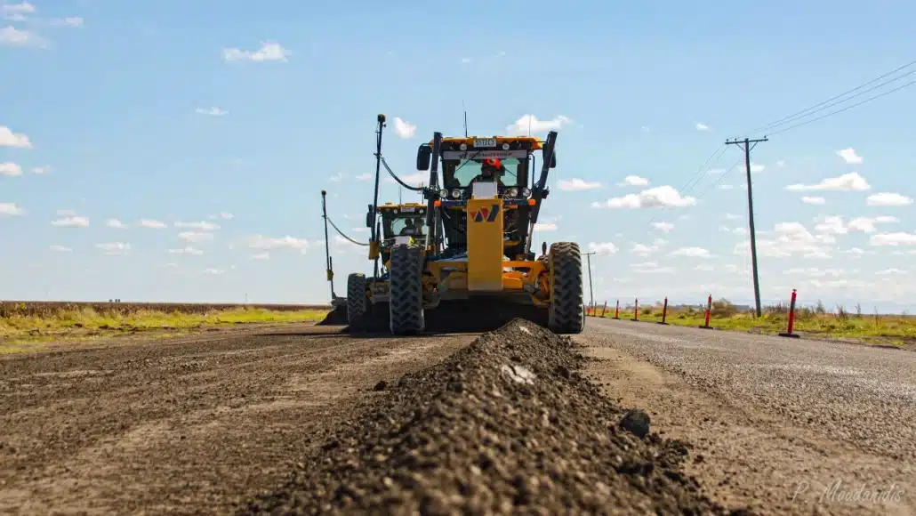
When you’re managing 20+ machine control systems across rail and civil projects, performance isn’t negotiable. For Joe Wagner Group, Topcon’s 3D-MC system – especially the new MC-Max grader setup and GX-90 control box – isn’t just meeting expectations. It’s redefining them. Simplicity in a Complex World In machine control, complexity is the enemy of productivity. While other contractors struggle with convoluted setups and fragmented workflows, Joe Wagner Group has found their competitive edge in Topcon’s elegant simplicity. “Out of all of the options on the market today, Topcon’s 3D-MC is the easiest to set up,” states Kobus Viljoen, Survey and Control Manager. “From file generation to data flow, nothing else comes close.” That simplicity starts in the design phase and
Topcon and Sokkia GNSS Introductory Offer 10% OFF Hiper XR & Sokkia GRX5 Introductory pricing on new Topcon and Sokkia, don’t miss your chance to get an accurate, reliable GNSS system. Save $3000 Topcon HiPer XR Calibration-free and immune to magnetic interference tilt compensation up to 60 degress GNSS interference monitoring and mitigation technology for anti-jamming and anti-spoofing Improved RTK performance for more reliable results Get Offer Sokkia GRX5 Sokkia Tilt Technology up to 60 degrees Anti-jamming and anti-spoofing capabilities 448 channels covering all modernised signals (GPS, GLONASS, Galileo, BeiDou, IRNSS, QZSS, SBAS) Available with integrated UHF radio Get Offer Fill out the form and we will contact you shortly Please enable JavaScript in your browser to complete

Sudden event detection with immediate alerts and photos Rockfall presents a serious risk to infrastructure, but with the right monitoring solution, you can detect early warning signs and respond before damage occurs. Our latest white paper explores how Senceive’s wireless monitoring technology provides real-time, automated alerts to help you manage rockfall risk effectively. What’s inside: • Traditional Rockfall Protection Methods • The Growing Need for Real-Time Monitoring • Senceive’s Rockfall Monitoring Solutions • Case Studies: Proven Success Download White paper Fill in the form to access the white paper Please enable JavaScript in your browser to complete this form.Name *FirstLastEmail *Phone Comment or Message Submit

In an industry that runs on precision, time, and tough conditions, Topcon software continues to earn its place as the preferred technology partner for construction professionals — and Aptella is at the heart of that success. At the core of Topcon’s appeal is a refreshingly simple truth: the software just works. Green Means Go: Simple Tech for Complex Jobs Topcon’s flagship solutions—Pocket 3D and 3D-MC—have become foundational tools across construction sites nationwide. Pocket 3D provides surveyors with comprehensive site management capabilities, allowing them to collect, verify and manage topographic data all from a handheld device. Meanwhile, 3D-MC transforms ordinary excavators, dozers and graders into precision instruments through sophisticated machine control technology that guides operators to exact grade

In the rugged hinterland of Australia’s Gold Coast, an engineering marvel is redefining adventure tourism. Happitat Adventure Park—the world’s first fully suspended cliff park—stretches across a breathtaking 200 metre vertical cliff face at Binnaburra in Lamington National Park, offering thrill seekers an unprecedented way to experience nature’s grandeur. This spectacular ecoadventure attraction immerses visitors in the ancient Gondwana rainforest while suspended high above the forest floor. Behind this groundbreaking achievement stands innovative surveying technology from Aptella that made the seemingly impossible not just possible, but crucially precise. A Vision on the Edge “The project we worked on is called Happitat Adventure Park, the world’s first cliff park,” explains Michael Neururer, Director of Naviq, the visionary company behind this

In the world of precision measurement, Topcon has long been synonymous with robust hardware. But the true revolution lies in a remarkable journey of software evolution—a transformation that mirrors the rapid technological changes of the past few decades. Not too long ago, surveying software was confined to tiny Windows Mobile field controllers with minimal memory and limited capabilities. Surveyors could barely load basic data, let alone complex design files. Fast forward to today, and the landscape has dramatically changed. With the advent of powerful tablets and sophisticated operating systems, surveyors now carry entire digital ecosystems in their hands—a far cry from the constraints of early mobile technology. “The software has moved past its original limitations,” explains Patrick Gilbert,

Monitor your mine for under $10K We recently hosted a webinar showcasing our new solution, Locator One, and how it enhances mine monitoring. If you missed the live session, you can watch the recording on demand by filling out the form below. In this short, informative session, Aptella’s Marketing Development Manager Andrew Jones will describe Locator One’s suitability for mining applications, which includes: 24 readings per day Fully owned infrastructure and data Wireless, solar-powered, low maintenance hardware Cost effective, scalable platform to suit your site requirements Local support and training provided through Aptella’s expert team Fill in the form to see the webinar! Please enable JavaScript in your browser to complete this form.Name *FirstLastCompany *Email *Phone * CountryCountryAustraliaAfghanistanAlbaniaAlgeriaAmerican

Leading automation and positioning specialist, Aptella, is collaborating with XGRIDS to bring the Lixel K1 and Lixel L2 Pro series of handheld laser scanners to customers across Australia, Southeast Asia, and New Zealand. The Lixel K1 and L2 series are designed for convenience and ease of use, enabling quick deployment across a wide range of applications. These compact, handheld devices integrate panoramic cameras and LiDAR technology to generate real-time, true-colour 3D models. The user-friendly design makes them suitable for professionals and 3D enthusiasts alike, providing an accessible solution for efficient and accurate data capture in industries such as construction, surveying, and facility management. “Our partnership with XGRIDS allows us to offer practical and efficient laser scanning solutions that